Foreign
Hurricane Milton Moving Away From Florida

Hurricane Milton Moving Away From Florida With High Winds, Flooding Rain, Storm Surge
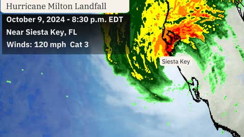
Updates: Hurricane Milton made landfall Wednesday evening south of Tampa Bay in Siesta Key, Florida, but it’s now centered off the state’s Atlantic coastline about 75 miles east-northeast of Cape Canaveral.
Rainfall is moving offshore, but strong, gusty winds continue in its wake along Florida’s Atlantic Coast.

Earlier this morning, winds along the Atlantic Coast gusted up to 92 mph in Marineland, 87 mph in Daytona Beach and 76 mph at South Hutchinson Island.

(The red icon depicts the center of Milton as of the most recent advisory.)
Here’s what to expect next from Hurricane Milton :
The hurricane will continue to track farther into the Atlantic by later Thursday morning and afternoon

Rainfall and strong wind gusts will continue ease up across the state through the day as Milton pulls away from the state and heads out to sea.

(The red-shaded area denotes the potential path of the center of the tropical cyclone. It’s important to note that impacts (particularly heavy rain, high surf, coastal flooding, winds) with any tropical cyclone usually spread beyond its forecast path.)
Storm surge inundated some areas of northeast Florida’s coast because of strong winds blowing onshore this morning. Moderate to major flooding was reported along the St. Johns River from a combination of storm surge and heavy rainfall.
More storm surge flooding is expected this afternoon and evening with high tide in northeast Florida.

Recap Of Milton So Far
Here’s the storm formation, intensity and track history for Milton: Tropical Depression Fourteen formed on the morning of Oct. 5 in the southwest Gulf of Mexico and shortly thereafter was deemed Tropical Storm Hurricane Milton .
The storm then rapidly intensified into Hurricane Milton about 24 hours later at 1 p.m. CDT on Oct. 6.
The next day, Milton underwent another incredible round of rapid intensification. Winds increased from 90 mph at 1 a.m. CDT on Oct. 7 to 180 mph just 15 hours later at 4 p.m. CDT.

Milton’s 180 mph winds made it one of only nine other Atlantic hurricanes to hit that wind threshold or higher.
Its pressure dropped to 897 millibars, the lowest observed in any Atlantic hurricane since Wilma in 2005. That also ranks as the fifth-lowest pressure on record for any Atlantic hurricane.
After weakening to a Category 4 the night of Oct. 7 because of an eyewall replacement cycle, the hurricane regained Category 5 intensity over the Gulf of Mexico on the afternoon of Oct. 8.
Milton held at that strength into the morning of Oct. 9 before increasing wind shear caused its winds to weaken on approach to Florida.
The hurricane milton then made landfall south of Tampa Bay as a Category 3 at 8:30 p.m. on Oct. 9.

Hurricane Milton ‘s landfall storm reports history:
Numerous tornadoes were spawned by Hurricane Milton in southern and central Florida ahead of its landfall Wednesday. There have been at least three dozen reports of tornadoes, but the actual number of twisters won’t be known until the National Weather Service performs storm surveys.
A flash flood emergency was issued Wednesday evening because of heavy rain in Pasco, Hillsborough and Polk Counties, including Lakeland, Winter Haven and Wesley Chapel. Rainfall totals in the area were estimated to be 8 to 12 inches.
Rainfall totals of 10 to 17 inches soaked southern Pinellas County, coastal Hillsborough County and western Manatee County.
St. Petersburg, Florida, reported more than five inches of rain in just one hour along with a gust to 90 mph in that hour. Parts of downtown Tampa and St. Petersburg flooded due to as much as 17 inches of rain.
Tampa broke its monthly rainfall record in just one day by receiving over 11 inches of rain. That record had stood for over 100 years. Waist-deep water was reported in St. Petersburg and Tampa due to rainfall-driven flooding.
Water levels rose about 8+ feet near Sarasota close to landfall Wednesday evening. A storm surge of 3 to 6 feet was been recorded from Naples to Charlotte Harbor, with more inundation likely occurring in Manatee and Sarasota counties. Water levels fell by around 5 feet at the top of Tampa Bay due to blowout winds while the mouth of Tampa Bay saw a climb in water levels by 1 to 2 feet. Naples saw a storm surge of 5.75 feet.
Hurricane milton-force winds swept through much of Central Florida.
Winds gusted up to 105 mph in Egmont Channel, 102 mph in Sarasota, 101 mph in St. Petersburg, 97 mph in Venice, 93 mph in Tampa and 90 mph in Venice. A sustained wind of 78 mph was recorded in Venice at an elevated station. St. Petersburg’s Tropicana Field and several cranes in downtown suffered serious damage.
To the east, Orlando International Airport recorded a wind gust to 86 mph.


